

Files
Download Full Text (6.0 MB)
Description
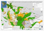
Mapa de Territorios Indígenas y Áreas Naturales Protegidas en las Fronteras Amazónicas entre Ucayali y Madre de Dios (Perú), Acre (Brasil) y Pando (Bolivia)
Map of Indigenous Territories and Protected Areas in the Amazon Borders between Ucayali and Madre de Dios (Peru), Acre (Brazil), and Pando (Bolivia)
Publication Date
2013
Keywords
Amazon, transboundary, Peru, Ucayali, Acre, Brazil, Bolivia, Pando, Madre de Dios, maps, protected natural areas, Amazon borders, indigenous territory
Language
Spanish, Portuguese
Disciplines
Environmental Studies | Geographic Information Sciences | Geography | Physical and Environmental Geography
Recommended Citation
Grupo Geográfico Transfronterizo de la Amazonía Sud Occidental (GTASO). 2013. Mapa de Territorios Indígenas y Áreas Naturales Protegidas en las Fronteras Amazónicas entre Ucayali y Madre de Dios (Perú), Acre (Brasil) y Pando (Bolivia). Rio Branco, Acre, Brasil: Instituto Panamericano de Geografía e Historia.
Included in
Environmental Studies Commons, Geographic Information Sciences Commons, Physical and Environmental Geography Commons

Comments
More information available at https://blog.richmond.edu/dsalisbury/.