

Files
Download Full Text (5.5 MB)
Description
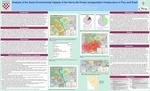
Located in the remote southwestern Amazon, the Sierra del Divisor mountain range divides the Ucayali and Jurua Watersheds and separates the urban centers of Pucallpa, Peru and Cruzeiro do Sul, Brazil. Both Pucallpa and Cruzeiro do Sul serve as economic hubs for their region, but are each the end of the road, as beyond them rivers remain the main means of transportation (figure 1). The Sierra del Divisor region includes indigenous territories, forestry and mining concessions, a reserve for the “uncontacted” Isconahua people, the Serra do Divisor national park in Brazil, and a proposed Peruvian national park, currently the Sierra del Divisor reserved zone: a transitional category (figure 1). The Brazilian Park embraces the Peruvian border and hosts a “spectacular” number of rare and endemic species (Vriesendorp et al. 2006), including jaguar, white-lipped peccaries and the red Uakari monkey (Salisbury et al. 2013). In addition to fauna and flora, the region also holds cultural diversity with descendants of the Asheninka, Nawa people, rubber tappers, and the “uncontacted” Isconahua people. Indigenous communities and small villages line the rivers. In the last decade, loggers, miners, and drug traffickers have become more visible, even as populations in both cities continues to grow (Salisbury et al. 2013). Simultaneously, plans to bridge the ecologically and culturally diverse region between the cities with transportation infrastructure continue to coalesce.
Publication Date
4-9-2013
Conference Date
Association of American Geographers, Los Angeles, CA, April 9-13, 2013
City
Los Angeles, CA
Disciplines
Geographic Information Sciences | Geography | Physical and Environmental Geography
Recommended Citation
Appling, George, and David S. Salisbury. "Analysis of the Socio-Environmental Impacts of the Sierra del Divisor transportation infrastructure in Peru and Brazil." Association of American Geographers, Los Angeles, CA. April 9-13, 2013.
